Table of Contents
Early Panoramic maps & bird’s‑eye views offered early travelers, city planners, and curious onlookers a way to experience landscapes from above — expansive, atmospheric, and rich with cultural detail. Long before cameras could sweep across a horizon or stitch together digital frames, artists and cartographers were already imagining the world in wide format. These early wide‑angle visions were the first attempts to capture the world “as a panorama,” revealing not just geography but the spirit of place.
The Origins of Wide‑Format Storytelling
Panoramic maps and bird’s‑eye views grew out of a moment when artists, cartographers, and travelers were rethinking how a place could be represented. Instead of compressing the world into symbols and measured lines, these wide‑format images aimed to recreate the feeling of standing above a landscape and taking it in all at once. They offered a narrative dimension that traditional maps lacked: the sweep of a river, the density of a city core, the way roads threaded outward toward distant hills. Early viewers treated these works almost like windows—expansive scenes that blended geography with lived experience, giving form to the growing curiosity about cities, territories, and the wider world.
A New Way of Seeing
Bird’s‑eye views introduced a perspective that was both impossible and deeply intuitive. Artists imagined themselves floating above rooftops and ridgelines, constructing elevated viewpoints that revealed the full structure of a place. This hybrid of observation and invention allowed them to show not only what a city looked like, but how it functioned—how people moved through streets, how harbors connected to trade, how natural features shaped daily life.
The compositions often highlighted:
- architectural landmarks — churches, courthouses, mills, and factories anchoring civic identity
- rivers, harbors, and coastlines — the lifelines of commerce and travel
- roads and trade routes — pathways that linked towns, markets, and regions
- cultural centers and public squares — the social heart of a community
- surrounding hills, forests, and farmland — the environmental context that sustained local economies
These images invited viewers to explore rather than decode. Every rooftop, shoreline, and winding road became part of a visual journey, encouraging people to wander through a place with their eyes and imagine its rhythms. They were early forms of immersive storytelling—precursors to modern panoramas, aerial photography, and digital mapping—capturing the world not just as it was, but as it felt from above.
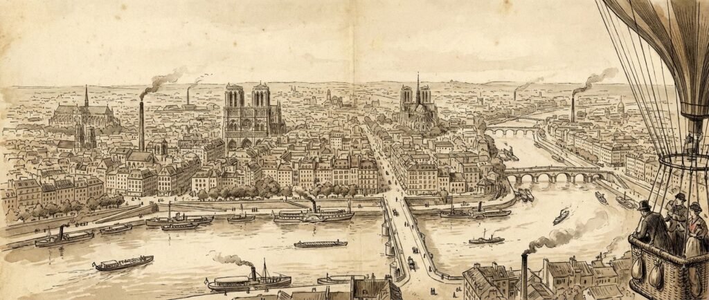
The Birth of the Bird’s‑Eye View
Bird’s‑eye views expanded the panoramic impulse by imagining a perspective that no human of the era could physically achieve. Artists lifted the viewer into an elevated, floating position, revealing the full geometry of a city—its street grids, waterfronts, industrial corridors, and surrounding countryside—in a single sweeping composition. This imaginative elevation wasn’t just a stylistic flourish; it reflected a growing cultural desire to understand place from above, to see how individual parts connected into a larger whole.
These wide‑format illustrations quickly became essential cultural artifacts. They supported tourism by showcasing cities as inviting destinations filled with recognizable landmarks. They fueled civic pride, often commissioned by towns eager to present themselves as prosperous, orderly, and forward‑looking. They served historical documentation, capturing the built environment at moments of rapid growth and transformation. They aided architectural planning, offering a visual framework for understanding how new structures fit into the urban fabric. And they enriched storytelling, giving artists and publishers a dramatic way to depict events, journeys, and regional identity.
In many ways, bird’s‑eye views were early exercises in panoramic imagination. They stitched together observation, memory, and artistic interpretation to create a sense of totality—an all‑at‑once understanding of place. Their influence carries forward into the sweeping cityscapes, stitched panoramas, and aerial perspectives that define how we visualize the world today.
Why Panoramic Maps Captured the Imagination
A Sense of Place
Panoramic maps conveyed the character of a location in a way that felt immediate and human. Architecture, street patterns, waterways, and surrounding terrain were woven into a single, unified image that showed how a city fit into its landscape. Viewers could understand orientation, scale, and spatial relationships at a glance, gaining a sense of how people moved through the environment and how natural features shaped daily life.
Cultural Storytelling
Artists filled these maps with small narrative details—ships docking, trains departing, market stalls bustling, smoke drifting from chimneys. These vignettes transformed the maps into cultural documents, capturing the rhythms of work, travel, and community. They blended cartography with illustration, turning geographic information into scenes of lived experience.
Visual Accessibility
Unlike technical maps that required specialized knowledge, panoramic maps were instantly readable. Their perspective-based approach made them intuitive for travelers planning routes, merchants assessing trade connections, and artists studying the character of a place. They democratized geographic understanding by presenting cities and regions in a form that anyone could interpret.
Early Panographic Thinking
Panoramic maps were essentially hand‑drawn panoramas—wide-format compositions that stitched together multiple viewpoints into a cohesive whole. They anticipated the principles that define modern panography:
- wide horizons — sweeping views that extend beyond a single vantage point
- layered depth — foreground, midground, and distance arranged to guide the eye
- spatial storytelling — landscapes presented as narratives rather than diagrams
- immersive perspective — a sense of standing within the scene rather than above it
These early maps were the first attempts to see the world “wide,” using imagination and observation to create expansive visual experiences long before cameras or aircraft made such views possible.
Bird’s‑Eye Views as Cultural Windows
Bird’s‑eye views offered a dramatic shift in perspective by imagining the world from an elevated, impossible height. That imagined elevation revealed patterns, relationships, and spatial logic that were invisible from the ground, turning everyday environments into coherent visual systems.
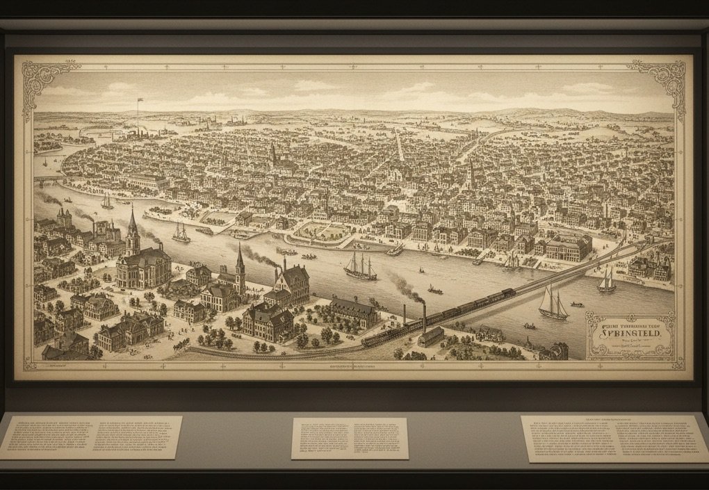
Urban Patterns
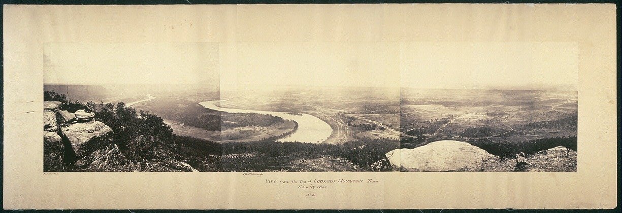
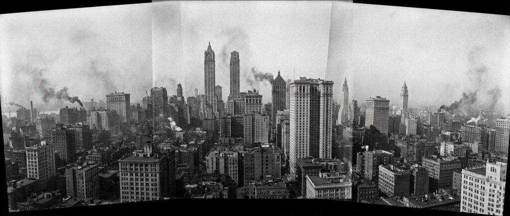
Cities became legible in new ways when seen from above. Grids, winding streets, waterfronts, rail lines, and public squares formed recognizable patterns that reflected a community’s history, economy, and cultural priorities. Bird’s‑eye views captured this structure with clarity, showing how neighborhoods connected, how commerce flowed, and how geography shaped urban life. They offered a holistic understanding of place long before aerial photography made such views real.
Natural Landscapes
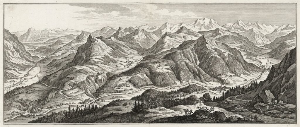
The same elevated perspective transformed natural environments into sweeping compositions. Artists emphasized ridgelines, river systems, forests, and agricultural fields, arranging them in layered depth that suggested movement and scale. These drawings conveyed the drama of mountain ranges, the openness of valleys, and the rhythm of coastlines, creating panoramic landscapes decades before cameras could capture such breadth. They revealed how natural features guided settlement, travel, and regional identity.
Travel and Exploration
Bird’s‑eye views became powerful tools for promoting destinations. By presenting cities and landscapes as inviting, navigable, and full of character, they encouraged travelers to imagine themselves entering a harbor, crossing a bridge, or strolling through a bustling district. This made them an early form of travel marketing—visual invitations that blended accuracy with aspiration, helping people picture the experience of being there.
Techniques Behind Early Panoramic Maps
Composite Perspective
Artists combined multiple viewpoints into a single, continuous image, shifting angles whenever necessary to reveal important architectural or geographic details. This composite approach let them show façades, street alignments, and landscape features that would be hidden from any single vantage point. It mirrors the stitched logic of modern panography, where multiple exposures are merged to create a seamless wide‑format view.
Exaggerated Elevation
To achieve the illusion of height, artists often depicted cities from an elevated position that didn’t exist in reality. Hills were imagined taller, horizons lifted higher, and viewpoints shifted mid‑scene. This blend of observation and invention created a commanding perspective that made the entire landscape legible at once, long before true aerial views were possible.
Layered Depth
Foreground, midground, and background were arranged with deliberate clarity, guiding the viewer’s eye across the scene in a smooth visual progression. Buildings, roads, waterways, and distant hills were placed in rhythmic layers, creating a sense of depth similar to what panoramic photography later achieved through lens curvature and wide‑angle composition.
Atmospheric Detail
Cloud formations, directional light, and cast shadows added mood and dimensionality to these maps. Atmospheric effects helped define time of day, season, and weather, making the scenes feel lived‑in rather than purely diagrammatic. This attention to light and atmosphere enhanced immersion, giving early panoramic maps the emotional resonance of landscape art as well as the informational clarity of cartography.
How These Early Works Influence Modern Panography
Wide‑Format Thinking
Early panoramic maps encouraged viewers to see landscapes as continuous, flowing environments rather than isolated points on a grid. That mindset carries directly into modern panography, where wide‑format images emphasize connection, movement, and the relationships between elements across a broad field of view. The idea of “seeing everything at once” remains central to how contemporary photographers compose expansive scenes.
Spatial Storytelling
Modern panoramic photographers still rely on the same visual principles that shaped 19th‑century bird’s‑eye views:
- leading lines — roads, rivers, and architectural edges that guide the eye
- layered depth — foreground, midground, and distance arranged to build dimension
- horizon flow — a continuous sweep that anchors the composition
- environmental context — the surrounding terrain that gives meaning to the scene
These techniques echo the visual language of early panoramic maps, where artists used similar strategies to help viewers navigate complex landscapes.
Cultural Documentation
Just as bird’s‑eye views captured the life of a city, today’s panographers document the character of a place through wide‑format imagery. Markets, festivals, architecture, coastlines, and historic districts become cultural records, preserving atmosphere and context in a single frame. The panoramic format allows for a richness of detail that mirrors the narrative density of early illustrated maps.
Artistic Inspiration
For sketchbook artists and painters, panoramic maps offer compositional ideas that translate beautifully into modern artwork. Their sweeping horizons, layered depth, and imaginative viewpoints provide a foundation for contemporary visual storytelling, whether rendered in pencil, ink, or paint. These early works continue to inspire artists who seek to capture the world in broad, expressive strokes.
Panoramic Maps in Museums and Travel Culture
Many museums and cultural institutions display panoramic maps as historical artifacts because they reveal how earlier generations imagined, organized, and interpreted the world. Their blend of accuracy, artistry, and narrative detail makes them invaluable records of cultural identity and geographic understanding.
Travelers often encounter these maps in:
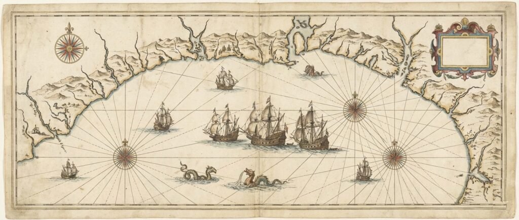
- maritime museums — where coastal cities, ports, and shipping routes appear as sweeping illustrated harbors
- city history centers — showcasing how urban form evolved through grids, rail lines, and waterfront development
- cultural archives — preserving hand‑drawn views that document regional growth and community life
- architectural exhibits — highlighting how early planners visualized spatial relationships long before modern surveying tools
Seeing these works in person reveals their scale, precision, and craftsmanship. The wide sheets, intricate linework, and layered depth make clear that wide‑format storytelling has deep historical roots. Panoramic maps were early attempts to capture the world in its fullness, and their presence in museums today underscores how foundational they are to the evolution of modern panography.
Frequently Asked Questions
What makes panoramic maps different from traditional maps?
Panoramic maps use artistic perspective to show landscapes and cities in wide, elevated views rather than flat diagrams.
Why were bird’s‑eye views so popular before photography?
They offered immersive, intuitive visuals that helped people understand the layout and character of a place.
How do panoramic maps relate to modern panography?
Both rely on wide‑format storytelling, layered depth, and multiple viewpoints to capture the spirit of a location.
Were panoramic maps accurate or imaginative?
They blended observation with artistic interpretation, creating images that were both informative and expressive.
Can panoramic maps inspire modern artists?
Absolutely — their compositions, textures, and perspectives offer rich inspiration for sketching, painting, and panoramic photography.
 Panography.org | CREATIVE INSPIRATION & VISUAL IDEAS
Unusual Perspectives | Seeing Panoramas Differently
Break free from standard compositions. This article highlights the beauty found in unconventional angles and daring wide-format visual experiments.
Final Thoughts
Panoramic maps and bird’s‑eye views were early expressions of a panoramic imagination — a desire to see the world in its full breadth, from horizon to horizon. These artworks captured not just geography but culture, atmosphere, and lived experience, offering viewers a sense of place long before cameras could do the same.
For today’s traveling artists and panoramic photographers, these early wide‑format visions remain deeply inspiring. They remind us that panography is not just a technique but a way of seeing — one that connects us to landscapes, cities, and cultural stories across time. Whether you’re sketching in a museum, photographing a coastline, or wandering through a historic district, these early maps invite you to look wider, think expansively, and embrace the panoramic spirit that has shaped human creativity for centuries.